Plant problems · autumn rain garden drainage diagnosis
Read Autumn Rain to Diagnose Garden Drainage
Use one autumn rain to map where water arrives, runs, ponds, and lingers, then separate surface delivery, compaction, restrictive layers, and deeper saturation.
Published Last updated
In this guide
- Choose a rain that can reveal a pattern
- Follow water from source to outlet during the rain
- Time how the garden recovers
- Separate surface failure from a deeper drainage limit
- Test the soil after saturation has passed
- Match the correction to the evidence layer
- Keep the diagnosis open until another storm agrees
- Diagnosis
Choose a rain that can reveal a pattern
Autumn offers a useful drainage window because deciduous cover is thinning, irrigation is usually less influential, and repeated cool-season rain can reveal where water actually travels. The aim is not to prove that a garden is wet after an exceptional storm. It is to observe delivery, movement, and recovery during a rain that is meaningful for the site, then compare those observations with a second event if the first was unusually intense, wind-driven, or preceded by saturated soil.
Set a straight-sided rain gauge in an open position and record the event's start time, pauses, and finish. A nearby official weather total can add context, but the garden gauge records what reached this property. Note the previous week's weather as well. A half-inch falling on already wet clay and the same amount falling after a dry month are different tests. If the soil is frozen, snow covered, or already flooded from a larger watershed, postpone the root-zone test and limit the visit to mapping visible flow.
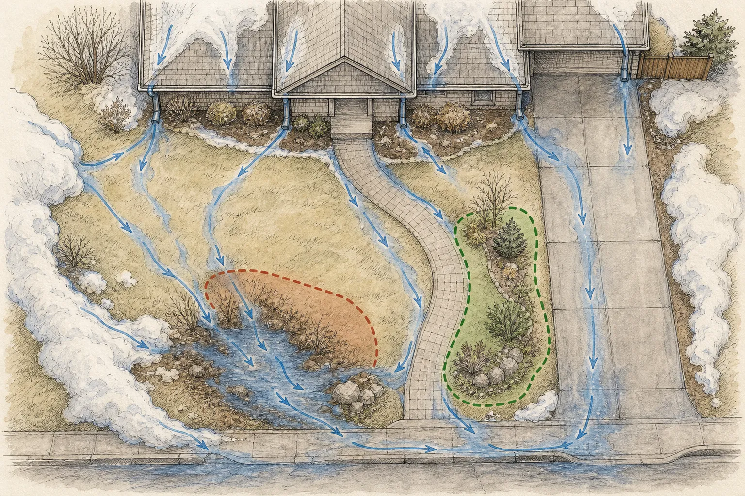
Prepare a base map before the rain. University of Georgia Extension recommends recording downspouts, drain lines, rapid water movement, and ponding during a downpour. Mark buildings, roof edges, paving, slopes, retaining walls, bed outlines, paths, low points, neighboring runoff, drain inlets, and any place where soil was recently disturbed. Number six to ten observation points from upstream to downstream. The map turns a wet impression into locations that can be revisited at fixed times.
Keep the investigation observational while soil is saturated. Walking, digging, wheel traffic, and dragging hoses across wet clay can create compaction or smear pore spaces, changing the condition being diagnosed. Photograph from firm paving or established paths. Where access is unsafe, water approaches the building, a retaining wall moves, a drain backs up, sewage may be involved, or erosion threatens property, stop the garden test and seek the appropriate drainage, structural, utility, or municipal expertise.
Follow water from source to outlet during the rain
Begin at the highest visible input. Watch each downspout, roof valley, sump outlet, neighbor-side opening, hose connection, and paved slope. The wettest bed may have ordinary soil but receive several times the rainfall falling directly on it because a roof or driveway concentrates water there. Draw arrows from each source and change the line style when water shifts from a narrow stream to sheet flow. A map that begins at the puddle misses the delivery system that may be causing it.
Trace the route across surfaces. Water may skim a sealed mulch crust, run along the joint between walk and lawn, disappear into one bed edge, or reappear lower on a slope. Watch for sediment fans, displaced mulch, tiny channels, leaves lodged against edging, and the clean scoured edge of a flow line. These marks show movement even when the rain briefly eases. Record whether water crosses a plant crown, collects against a raised edging board, or is diverted by a compacted footpath.
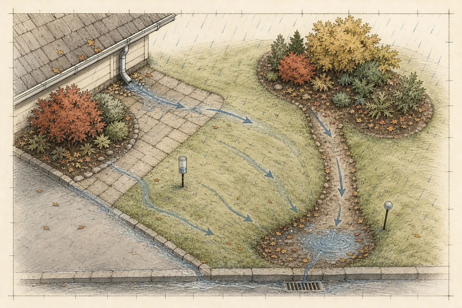
Finish at the outlet, including the possibility that no safe outlet is visible. A grate can be blocked; a swale can end at a fence; a pipe can discharge onto a lower bed; a curb opening can sit higher than the low point it is meant to drain. The water map should show continuity from source through garden to destination. Avoid opening an unknown drain, excavating near utilities, or redirecting water onto neighboring property during the observation. Those are design and legal questions, not quick field tests.
Repeat the circuit near peak rainfall and again as intensity declines. Water that appears only at the peak points to limited conveyance or infiltration capacity under high delivery. Water that continues entering after rainfall stops may come from a roof reservoir, uphill soil, a sump, or a delayed subsurface route. Timestamped images taken from the same positions make these differences visible and preserve evidence for a contractor or Extension consultation.
Time how the garden recovers
Start a recovery clock when meaningful rain ends, not when the first puddle appears. Check the marked points after roughly one hour, four hours, the next morning, and again around twenty-four and forty-eight hours when practical. Record surface water, softness at the edge, seepage from a slope, water in an inspection hole that already exists, and whether runoff routes remain glossy while surrounding soil dulls. The sequence matters more than a single photograph of a wet bed.
Distinguish an ordinary bed from a designed stormwater feature. Penn State notes that a rain garden should generally drain within about twelve to twenty-four hours and should not remain ponded beyond forty-eight hours. That maintenance threshold belongs to a rain garden designed to receive runoff; it is not permission for water to stand around the crowns of ordinary ornamentals for two days. In a standard border, duration must be judged against plant tolerance, soil temperature, prior saturation, and the depth and distribution of wetness.
Map the perimeter of each puddle at every check. A shrinking edge with a stable center suggests infiltration or an outlet that is slowly working. A puddle that expands after rain stops suggests delayed inflow from upslope, a roof system, or subsurface seepage. A surface that clears quickly can still conceal saturation below. Use a soil probe later, after wet conditions no longer risk smearing the hole, to compare the topsoil, original root ball, and deeper profile.
Plant symptoms are supporting evidence, not a drainage meter. Low vigor, yellowing, wilting, sparse roots, root or crown decline, algae, moss, and dieback can occur with poor aeration or compaction, but several other problems can produce the same appearance. University of Maryland Extension explains that water occupying pore spaces deprives roots of oxygen and that compaction reduces pore space, yet the observed distribution still has to connect symptoms to water behavior. Compare affected and unaffected plants of similar type before assigning a cause.
Separate surface failure from a deeper drainage limit
Surface runoff begins when rainfall arrives faster than the surface can accept it or when grading sends water across the soil. Look for a crust, bare polished soil, compacted traffic line, hydrophobic dry mulch, steep pitch, or water delivered from paving. If water moves sideways immediately while a nearby protected patch accepts rain, investigate surface condition and inflow first. Digging a deep drain would not correct a downspout aimed at a sealed bed edge.
Perched water appears when an upper layer accepts water but a denser layer below slows its descent. Construction compaction, a buried traffic pan, abrupt soil-texture change, smeared planting hole, or debris can create this pattern. The surface may clear while a probe hole or exposed root ball remains saturated above the boundary. Maryland Extension identifies high clay content, compaction, buried debris, high water tables, and restrictive layers among the explanations for slow percolation. Locate the depth of change before selecting a correction.
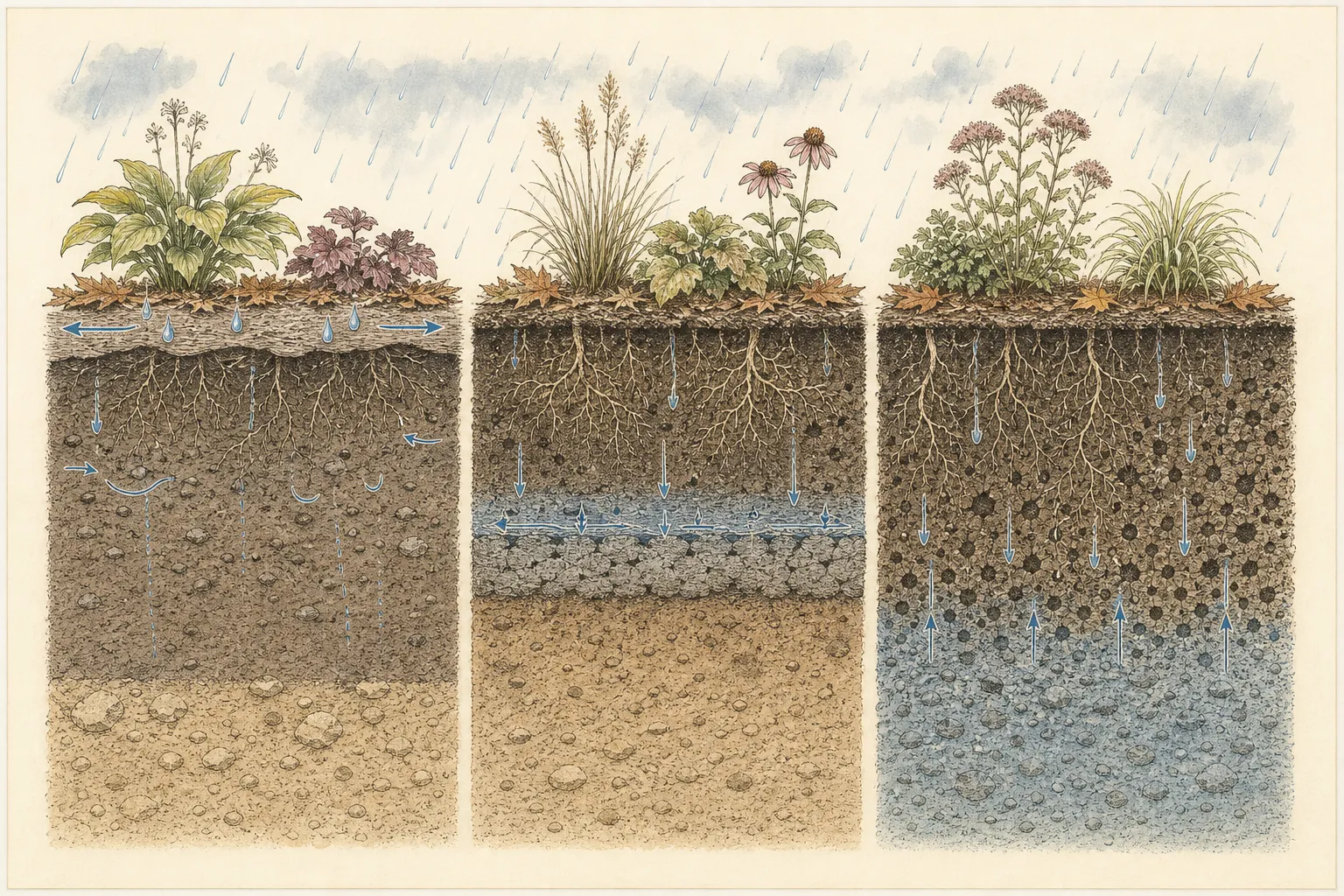
Deeper saturation behaves differently. Water may rise into an otherwise porous profile from a seasonal water table or move laterally from an uphill area. Several low points can become wet together, and a hole may refill from its sides or bottom after being emptied. A site-wide or off-site pattern needs broader hydrologic assessment. Installing a pipe without a lawful, lower, stable outlet can simply move the problem or create erosion. Foundation, retaining-wall, septic, and property-boundary conditions justify professional design.
A drainage map can show more than one cause. Roof water may overload a compacted bed, while a footpath blocks the only shallow outlet. Treat those as separate evidence layers: delivery, surface route, soil profile, and destination. A single label such as clay soil collapses the sequence and invites broad amendment without proving where resistance occurs.
Test the soil after saturation has passed
A percolation test is useful only when its method and scope are recorded. University of Maryland's home-landscape method uses a hole about twelve inches deep and twelve inches wide, fills it, allows it to drain, refills the next day, and then measures the fall. Its guidance treats less than one inch per hour as slow and more than four inches per hour as very sandy. The same source offers a simpler twelve-inch-deep, eight-inch-wide check in which the refill should drain within two to three hours. Use one documented method consistently rather than combining thresholds.
University of Minnesota describes a different tree-and-shrub test: a twenty-four-inch hole filled, drained, and refilled, with drainage within twenty-four hours—about one inch per hour—considered close to optimum for many landscape trees and shrubs. The different hole depths answer somewhat different root-zone questions. Record the chosen source, hole dimensions, presaturation, start depth, elapsed time, and site point. Compare several representative points because Georgia Extension notes that drainage can vary across one property.
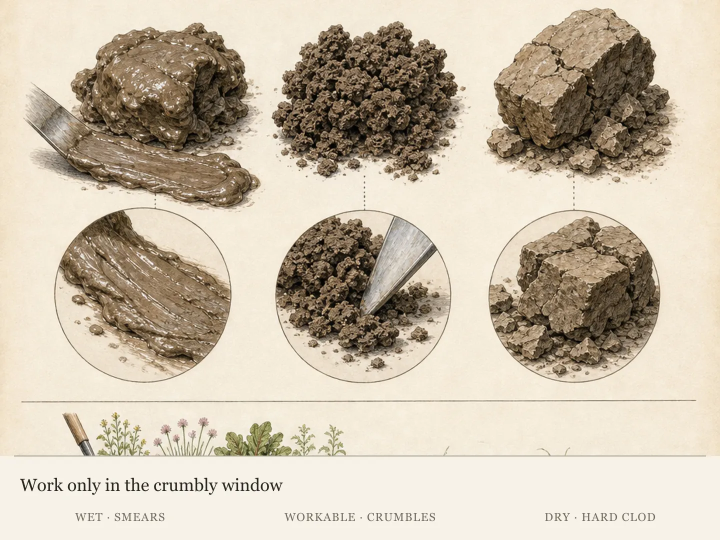
Wait until the ground can be handled without smearing. Maryland's simple workability check squeezes moist topsoil into a ball and bounces it lightly; soil that breaks into aggregates is dry enough to work, while a plastic mass is still too wet. Use a stiff wire or probe to compare resistance, and inspect an existing planting hole only where root damage can be avoided. The boundary between loose topsoil and dense subsoil often tells more than the color of the surface puddle.
Keep infiltration results in context. A fast hole beside a downspout does not cancel excessive delivery, and a slow test at one compacted path does not describe the whole bed. Tree roots, old trenches, fill pockets, buried construction material, and changes in grade can create sharp local differences. The test locates a limit; it does not automatically prescribe sand, compost, drains, or a rain garden.
Match the correction to the evidence layer
Correct concentrated delivery at its source when a safe compliant destination exists. A properly functioning downspout extension, repaired gutter, restored swale, or reopened surface outlet may remove more water from the bed than any soil amendment. Maintain positive drainage away from the building and confirm local stormwater rules before altering discharge. If the route crosses another property, approaches a foundation, or requires buried pipe, obtain qualified advice and utility location before excavation.
Address small accessible compaction only when soil moisture permits work. Maryland Extension suggests gentle garden-fork loosening for garden beds, moving the fork in short increments, and building organic matter through compost, mulch, and living roots. It also warns that adding fine sand to heavy clay can reduce pore space and slow drainage, while gypsum is not a general clay remedy for Maryland soils. These points support a measured soil-structure program, not a one-time recipe for every region.
Where a restrictive layer is confirmed, the scale and depth decide the response. A shallow construction pan in a new unplanted bed may be corrected during full bed preparation. A deep layer beneath established woody roots calls for restraint and specialist evaluation. Raising a future bed can place sensitive crowns above slow soil, but a raised island surrounded by a basin still needs an exit for water. Plant selection is a legitimate solution when the site's wetness is stable, lawful, and compatible with the building and access.
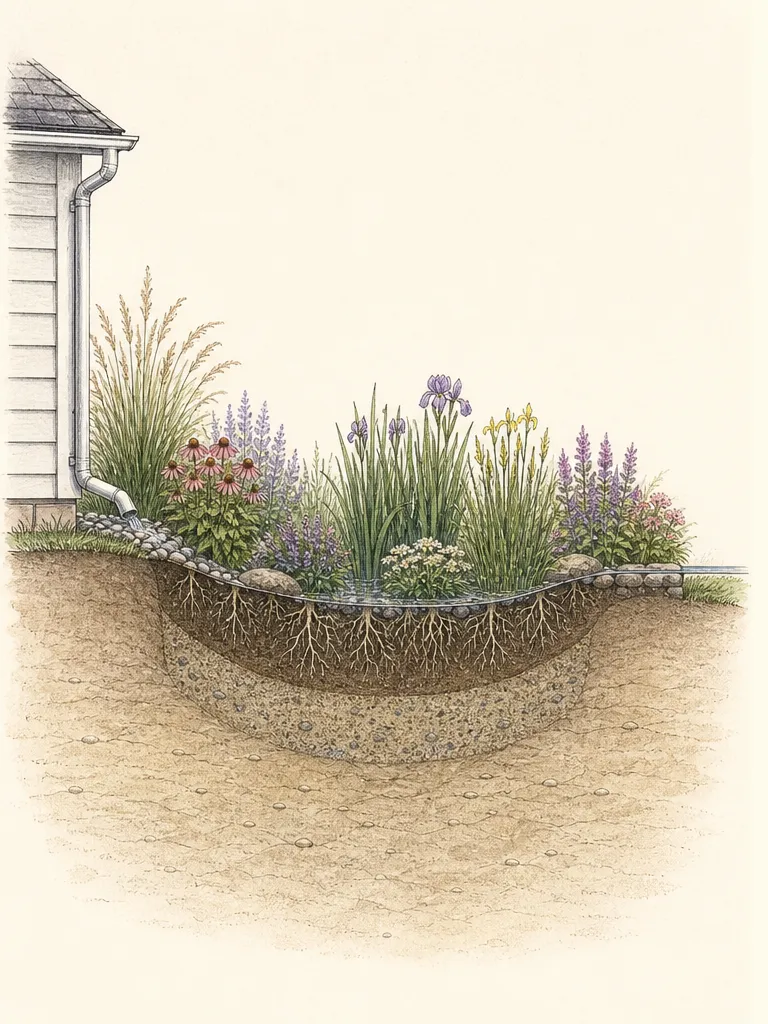
Use rain-garden logic only for a site designed to receive, spread, infiltrate, and safely overflow stormwater. A naturally wet hollow with a high water table is not automatically a rain garden, and a standard ornamental bed should not be turned into one by directing a downspout into it. Confirm setbacks, infiltration, overflow, utilities, foundations, and local rules. The autumn map supplies the evidence needed for that design conversation.
Keep the diagnosis open until another storm agrees
After the smallest justified correction, repeat the same observation points during a comparable rain. Record gauge total, antecedent moisture, peak route, ponding outline, and recovery times. Success is a changed pattern at the intended location without new erosion or saturation downstream. A puddle that is merely hidden by fresh mulch or topsoil has not been resolved; the paired map should show that delivery, movement, or drainage actually changed.
Leave one unaffected area as a control. If both treated and control points recover faster during a lighter storm, weather explains much of the difference. If only the treated downspout bed stops receiving concentrated flow, the source correction is visible. Plant recovery takes longer and may lag behind hydrologic improvement, so use new root growth, normal seasonal vigor, and reduced decline over time rather than an immediate flush of top growth as confirmation.
Escalate when the evidence exceeds a garden-scale correction: recurring water against the house, sinkholes, sewage odor, moving retaining walls, active erosion, inaccessible drains, deep saturation across a large area, or runoff tied to roads and neighboring land. Preserve the map, photographs, rainfall record, and test method for the professional. A clear autumn-rain record shortens the path from a vague complaint about wet soil to a defined question about source, route, depth, and outlet.
Diagnosis
Water skims across bare soil, mulch, or a compacted path almost as soon as rain begins, while nearby protected soil accepts water. Sediment fans, polished crusts, tiny channels, or displaced mulch mark the route. The surface may look dry again soon after the event even though little water entered the intended root zone.
- Check
- During rain, compare a compacted travel line with an undisturbed patch at the same elevation. Trace when runoff begins, photograph crust and sediment, and later test several points with one documented percolation method. Check workability before probing so the test itself does not smear wet soil and create a false boundary.
- Cause
- Rainfall is exceeding surface infiltration because the crust is sealed, the path is compacted, mulch has shed water, or slope concentrates sheet flow. Repeated wet traffic and construction pressure reduce pore space. A surface barrier can create runoff even when the deeper soil would transmit water once it entered.
- Action
- Reduce traffic on wet soil, restore a stable path, protect bare soil, and loosen small accessible compacted bed areas only when the soil crumbles rather than smears. Build structure gradually with locally appropriate organic matter and living roots. Fine sand and gypsum are not universal cures; use laboratory and Extension guidance for the actual soil.
A bed beside the house becomes much wetter than the surrounding garden. Flow begins at a downspout, roof valley, sump outlet, paved edge, or uphill opening and continues along the wall or across plant crowns. Ponding can occur even where a later percolation test shows acceptable soil because delivery is concentrated.
- Check
- Trace the water all the way upstream. Measure local rainfall, observe the downspout or paved source near peak intensity, and mark the route to its final outlet. Compare the wet bed with a similar area receiving direct rain only. Inspect gutters and visible connections without opening unknown drains or excavating near utilities.
- Cause
- Roof and hardscape area is delivering more water than the bed receives from direct rain. A short, disconnected, blocked, or poorly aimed outlet concentrates that volume at the foundation. The receiving soil may be adequate under ordinary rainfall yet overwhelmed by an artificial catchment several times larger than the bed.
- Action
- Repair the delivery source and route water away from the building to a safe lawful destination. The appropriate measure may be gutter repair, a correctly sized extension, restored swale, or professional drainage design. Keep discharge off neighboring property and away from unstable slopes, septic areas, utilities, and ordinary beds not designed to receive runoff.
Water gathers repeatedly in one shallow low point or behind edging, a path, or a berm. The puddle perimeter may shrink steadily after rain, and soil elsewhere in the same bed recovers faster. Leaves, sediment, or an outlet slightly above the basin floor reveal that local grade and conveyance are part of the pattern.
- Check
- Mark the puddle edge when rain ends and at repeated intervals. Survey the surrounding grade with a straight board and level or obtain professional measurement where precision matters. Clear only removable surface debris from a known outlet, then observe whether the basin drains without creating erosion farther down the route.
- Cause
- Microtopography or a blocked surface outlet is trapping water. Settled soil, raised edging, wheel ruts, path crowns, poorly placed berms, sediment at a grate, or an incomplete swale can create a small basin. Soil permeability may influence duration, but the basin geometry explains why water collects at that exact point.
- Action
- Restore the intended surface route where the cause is a small local obstruction or settled grade, preserving a stable non-eroding outlet. Remove accumulated sediment from a known inlet and correct edging that dams water. Broader regrading, work near structures, or any change that redirects runoff beyond the property needs qualified design and local compliance.
The surface clears, yet a probe hole, planting pocket, or root zone remains saturated above a consistent depth. Water movement slows abruptly at dense subsoil, construction fill, buried debris, or a smeared interface. Plants may decline in a band that follows the restrictive layer rather than the visible surface contour.
- Check
- After saturation passes, compare soil resistance and moisture above and below the suspected depth at several locations. Use the Maryland twelve-inch method or another locally approved test exactly as published and record dimensions and timing. Look for construction fill or debris while protecting established roots and stopping before utility depth.
- Cause
- A restrictive layer is perching water above it. Likely candidates include compacted subsoil, high clay content, construction traffic, abrupt fill, buried rubble, or a smeared planting-hole wall. Water can infiltrate through the top layer and then spread sideways, leaving roots saturated even after the visible puddle disappears.
- Action
- Match intervention to the restrictive layer's depth and the presence of roots. Full bed preparation may relieve a shallow pan before planting; established woody beds often require an arborist, soil specialist, or drainage professional. A raised future bed can protect crowns only when surrounding water still has a safe route and the plant palette suits the site.
Several low areas become wet together, and holes refill from the sides or bottom after surface water is removed. Seepage may continue after rainfall stops. The pattern crosses bed boundaries or follows a broad contour, suggesting a seasonal water table, lateral subsurface flow, or a larger drainage system beyond one planting hole.
- Check
- Check several points across and upslope from the bed, noting whether holes refill from below or seepage continues after rain. Compare maps from more than one event. Because foundations, retaining walls, septic systems, property drainage, and deep excavation carry wider consequences, bring the evidence to a qualified local professional.
- Cause
- The limiting condition is deeper or broader than the bed: a seasonal high water table, lateral seepage from upslope, an obstructed drainage network, or landscape-scale grading. A new pipe has no value without a lawful lower outlet and may transfer water to another vulnerable location.
- Action
- Treat broad or rising saturation as a site condition that may require hydrologic and civil evaluation. Select wet-tolerant ornamentals only where prolonged moisture is compatible with structures and use. A rain garden is appropriate solely after setbacks, infiltration, overflow, utilities, and local rules confirm that the location can safely receive stormwater.
One or several ornamentals show wilting, yellowing, sparse roots, crown decline, algae nearby, or reduced growth without a clear surface-water pattern. Symptoms intensify after wet periods but could also reflect planting depth, root-ball texture, drought, disease, soil chemistry, or other stresses. The plant alone does not locate the drainage failure.
- Check
- Compare affected and unaffected plants of the same species, including planting depth, root-ball moisture, crown exposure, soil smell and structure, and symptom timing. Review weather and irrigation records. Seek plant-diagnostic help when roots are decayed, vascular tissue is discolored, or symptoms progress despite corrected water delivery.
- Cause
- Root stress may involve poor aeration or compaction, but drainage is only one hypothesis. The original root ball may stay wetter or drier than surrounding soil, the crown may be buried, roots may be damaged, or a disease or chemical problem may be present. Several causes can coexist and require plant-specific diagnosis.
- Action
- Stabilize water delivery and root-zone moisture, then pursue plant-specific diagnosis rather than stacking treatments. Correct planting depth or root-ball mismatch when confirmed, remove only clearly failed tissue, and avoid fertilizer as a response to waterlogged roots. Track recovery through new roots and normal seasonal growth across subsequent weather.
Related reading
Sources
- Drawing a Landscape Plan - Site Analysis. University of Georgia Cooperative Extension. Source record · Accessed 2026-08-20.
- Common Soil Problems. University of Maryland Extension. Source record · Accessed 2026-08-20.
- Lawn Problems Not Caused by Pests or Diseases. University of Maryland Extension. Source record · Accessed 2026-08-20.
- How to Manage Flood Damage to Trees. University of Minnesota Extension. Source record · Accessed 2026-08-20.
- Best Practices for Rain Gardens. Penn State Extension. Source record · Accessed 2026-08-20.